
![[Athena]](gifs/athena.gif)
![[Curriculum]](gifs/curric.gif)
![[Earth Resources]](gifs/land.gif)
| Cartography - |
| the Art of Making Maps, the Science of Where You Are |
 |
Hundreds of years ago, our ancestors had only a vague idea of how large our world is. Many brave sailors and travelers set out to explore the world, and some were never able to return to their homes. |
|
Christopher Columbus and Ferdinand Magellan both sailed west from Europe
hoping to reach the fabulous spice-producing region of Southeast Asia.
For each, the world was a larger place than they imagined:
Columbus found a continent and Magellan crossed our world's widest ocean.
These seafarers had the best maps of their time, but the maps could not show what was not known. Their voyages would have been very different if only they had known what we know today. |
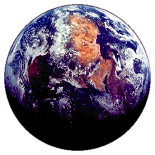 The Earth photographed by an astronaut on Apollo 11. |
| A map is a way to show information. The cartographer makes the map to show the information he or she wants to present. A map might: | |
|
The Earth is a sphere, so we cannot make a map that shows all of it at once without distortions. Cartographers have designed many different ways of mapping the Earth (these are called projections). Most maps have north at the top, south at the bottom, east to the right, and west to the left, but not always. |
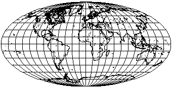 |
In this elliptical projection, the Earth's surface is stretched so that the continents have about the right shape and size (although Antarctica is too big). |
| In this familiar rectangular projection longitude and latitude are used as x and y values for a graph. This kind of map is easy to draw, but the continents are distorted. The distortion is less near the equator and becomes greater to the north and south. After all, in this projection, the north and south poles are not points, but the lines at the top and bottom of the map! | 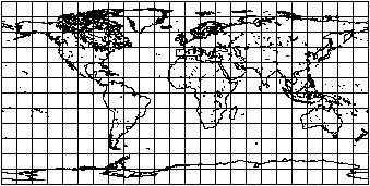 |
|
|
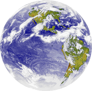 |
The scientists who processed the data from this camera first took
all the data points warmer than a certain temperature and assumed
those points were ocean or land.
Using a map, they colored these data points blue if they were ocean
and green or brown if they were land.
They assumed that all the rest of the points were clouds. In the Earth's atmosphere, the higher you go the colder it is. Clouds high in the atmosphere are cold and clouds low to the ground are warmer. The scientists colored the warm cloud points gray and the colder cloud points white. |
Zoom down to Maps of North America and the USA.
Western Hemisphere from Space - Los Alamos National Laboratory presents an image derived from an infrared camera on the NOAA GOES-6 satellite.
Line Maps - Xerox PARC Map Viewer allows you to view maps of any portion of the Earth.
![[Feedback]](gifs/feedback.gif) Tell us what you think about this page.
Tell us what you think about this page.