
![[Athena]](gifs/athena.gif)
![[Curriculum]](gifs/curric.gif)
![[Earth Resources]](gifs/land.gif)
| Cartography - |
| the Art of Making Maps, the Science of Where You Are |
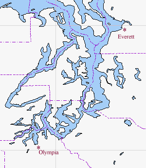
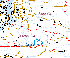
 In this map of the Puget Sound area, county boundaries are drawn in
purple. Coloring the water light blue to makes it
easier to see the islands and twisting waterways in the Puget Sound.
We've also marked the locations of Olympia (the Washington state
capital) and Everett (where the Boeing Company builds 747's).
In this map of the Puget Sound area, county boundaries are drawn in
purple. Coloring the water light blue to makes it
easier to see the islands and twisting waterways in the Puget Sound.
We've also marked the locations of Olympia (the Washington state
capital) and Everett (where the Boeing Company builds 747's).
|
|
|
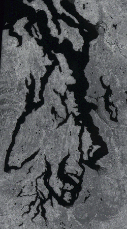
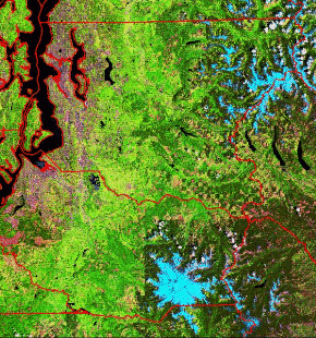
Unlike the false color vegetation map in "Maps of Washington State,"
this Landsat image of the Puget Sound uses data from only one
wavelength (color of light).
Lighter colors mean that more light is reflected.
1. Compare the image to the map above and, using the shapes of the islands and harbors of Puget Sound, locate Olympia and Everett in the Landsat Image.
2. Trace a course in the Sound you could take from Everett to
Olympia by sailboat.
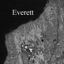
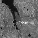
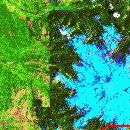
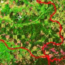
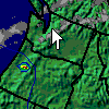
(In these city images, taken from the full size image (caution: 2Mb!), you can see the larger roads and buildings.) 3. Did you chart the most direct course, or did you take "scenic routes" around an island or two? |
|
| Scientists using Landsat data can combine the various wavelengths to make a false color image of land use. At this scale, evidence of human activities is easy to see. |
|
 The larger image is 112kb. |
This image uses a different color scale than the one used to
show vegetation.
|
|
|
This outline map shows much the same region as the image above. |
|
| Natural process have a level of randomness to them. Consequently, natural boundaries often have complicated lines and surfaces. Shorelines are hardly ever straight and large boulders are usually rough. On the other hand, man-made boundaries are usually straight, unless they are based on natural boundaries, such as rivers. Man made objects, like buildings, are almost always regular and usually rectangular. |
|
Use the Landsat Land Use image and the line map above to answer these questions.
|
West of Mt. Rainier (see the line map), is a straight boundary with dark green on the east and light green on the west. Do you think this boundary is natural or man-made? If man-made, what human activities do you think occur on each side of this boundary? |
|
In the southeast portion of King County is an area which has a "checkerboard" pattern of dark green and light green/tan. Do you think this is evidence of human activity, and if so, what activity is occurring? |
This is a shaded topographic map of western Washington.
The colors in this map indicate altitude instead of land cover.
A shaded relief map has been added to the color to make it easier
to see land forms and for visual appeal.
Using a small portion of the full altitude
color scale,
you can see that the passes east from the low Puget Sound region
through the Cascade Mountains to the eastern desert
are about 3000 ft high.
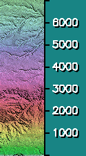 |
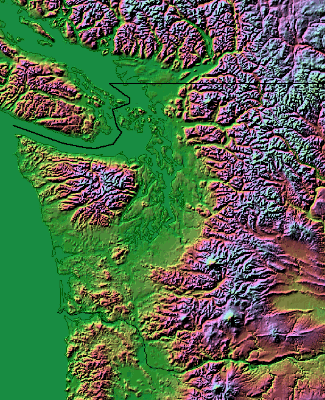 The larger image is over 350kb. |
| Weather in the Puget Sound region is frequently cloudy, especially in the winter months. The bottom of the cloud deck is often around 3000 ft. If the bottom of the cloud deck is not above the passes through the mountains, a small plane pilot must travel south to the Columbia River and then west through the Columbia River Gorge to get to Eastern Washington. |
|
ID   TIME   T  TD  RH DIR SPD GST ALT SLP VIS CIL COV WX  MAX MIN  PR6 PR24 SC
KSEA 0756  45  44  97 220   7     986 114 2.5   5 OVC R-   52  45
KSEA 0856  45  42  89 220   9     989 122  10  23 OVC
| Code | Meaning | Example |
|---|---|---|
| ID | Station identifier | KSEA |
| TIME | Universal time | 0756, (subtract 7 hours for Pacific time - 4 minutes to 1am) |
| T | Temperature (degrees Fahrenheit) | 45 degrees |
| TD | Dew point (degs F) | 44 degrees |
| RH | Relative humidity (%) | 97% |
| DIR | Wind direction (degrees) | 220 degrees (from the southwest) |
| SPD | Wind speed (miles/hour) | 7 miles/hour |
| GST | Gust speed (miles/hour) | No gusts |
| ALT | Altimeter setting (inches of Mercury; add a 2 in front) | 29.86 inches |
| SLP | Pressure (millibars; add a 10 in fron) | 1011.4 millibars |
| VIS | Visibility (miles) | 2.5 miles |
| CIL | Ceiling (hundreds of feet) | 500 feet |
| COV | Cloud cover (overcast, broken, scattered, or clear) | overcast |
| WX | Weather | R- is light rain |
| MAX | Maximum temperature in past 6 hours | 52 degrees |
| MIN | Minimum temperature in past 6 hours | 45 degrees |
| PR6 | Precipitation in the past 6 hours | None |
| PR24 | Precipitation in the past 24 hours | None |
| SC | Snow cover | None |
This report for Seattle tells us that at 0756 UT (00:56 PDT) the temperature was 45 degrees, the dewpoint temperature 44, wind from 220 degrees(SW) at 7 mph with no gusts. The aircraft altimeter setting was 29.86" Hg, (pressure 1011.4 millibars), 2.5 mile visibility, 500 ft overcast, weather (WX) light rain, the max and min temperatures in the preceding 6 hours were 52 and 45, no precipitation in the preceding 6 or 24 hours, and no snowcover.
Another source of data for Puget Sound is the Decoded Observations from the Station List from the National Weather Service Forecast Office in Seattle.
Zoom down to Maps of the Seattle Area.
Zoom back up to Maps Washington State.
Topographic map -Color Landform Atlas, copyright and courtesy Ray Sterner, Johns Hopkins University/Applied Physics Laboratory
Line Map - Xerox PARC Map Viewer allows you to view maps of any portion of the Earth.
Landsat photo - USGS EROS Data Center allows you to browse and select images.
![[Feedback]](gifs/feedback.gif) Tell us what you think about this page.
Tell us what you think about this page.